If you have good bandwidth, Please join us in
the following slide show to give Gibraltar the
viewing it deserves by clicking here.
|
|
The world's most strategic rock

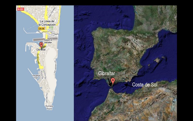
We spent 3 weeks based on the Costa del Sol in the middle
portion of the bottom of Spain. This is pretty much
Europe's Florida. Afterward, we started two weeks of
wandering and Gibraltar was our first stop.
Twenty miles from Africa, Gibraltar is not the closest
part of Europe to Africa, but cannon mounted here could
control the narrow Strait. it's been a British colony
although Spain has tried to get it back many times. The
Brits are not about to give it up. By the 1920s, their
empire ruled nearly a quarter of the world's population
and this strategic point controlled the main path from
Britain to its Asian realms.

We approached on one of Spain's superhighways -- but
without much signage telling us we were approaching
Gibraltar. Hundreds of ships lay at anchor awaiting their
chance to unload in the busy Spanish and Gibraltar ports
here. This is a thriving area, fueled in large part by a
real estate boom that raises cranes on what seems like
every block. However, the Spanish economy is now in
somewhat of a free fall due to the world-wide
recession.

The east (left) slope faces the Mediterranean and is
virtually unscalable. The west slope is still very steep
but supports a town of about 25,000 clinging to its base
on the Bay of Gibraltar. The foreground here are the
Spanish towns of Linea de la Concepción and
Algeciras. The Rock here looks impregnable and solid; in
fact, it's a crackling bit of limestone pockmarked by
huge natural caves and man made tunnels.

Many ships lay at anchor for their turn to load and
unload at Gibraltar docks or across the bay at Algeciras,
the largest port in Spain. Both sides of the bay have
Neanderthal remains from Paleolithic times. The
current town of Algeciras traces its roots back to
Gibraltar inhabitants who fled their tiny peninsula when
the British and Dutch captured it in 1704 (and the Brits
wouldn't leave.)
The bay's most recent wartime activity was an attempt by
the Argentinians during the 1982 Falklands war to use
frogmen to plant magnetic mines on British warships. The
Brits intercepted and decrypted their communications and
the Spaniards arrested the frogmen and sent them back to
Buenos Aires before anything happened. The Argentinians
weren't all that original as Italian frogmen frequently
attacked Gibraltar during WWII.

The economy is not for the birds
On a clear day, it's easy to sea Africa about 20 miles to
the south. This is the biggest bird highway for the
seasonal migrations from Europe to Africa.

Above we see Africa in the distance framed by that
vanishing Iberian bird, the building crane.
Gibraltar, however, is booming and its mayor boasts it
has the best economy in the world. Military activity (60%
of GDP in the 1980s) now accounts for only 7% of its GDP.
(During WWII it was 100% as civilians were evacuated.)
Growth industries include online gambling and, of course,
shopping as there is no VAT here. Europeans typically pay
Value Added Tax of 15% to 25% on most retail
purchases.
Peak experiences

Let's start at the top: At lower left is a typical white
van, about the only transportation allowed beyond the
town at the base of the Western side of the Rock. (A
cable car also climbs this hill). These disgorge tourists
at the various sites stacked on this 1400 feet of
limestone. At left is the Bay of Gibraltar on the
Mediterranean.
At top is the Tower of Homage of the Moorish castle whose
walls enclosed this area down to the sea. The Moors
occupied Gibraltar longer than anyone else, about twice
as long as the Brits (so far) who have been here now
longer than the Spanish who still claim this as their
territory. The Moors arrived in 711, sneaking into the
southern part of the peninsula today called The Great
Europa Point. The building here was rebuilt in the 14th
century when the Moors, expelled by the Spanish for about
25 years, recaptured the peninsula.

The steep road still holds rings used by the British to
pull their heavy cannons into position. Typically these
are secured by foot-long spikes grasped by molten lead
crammed into the porous limestone.
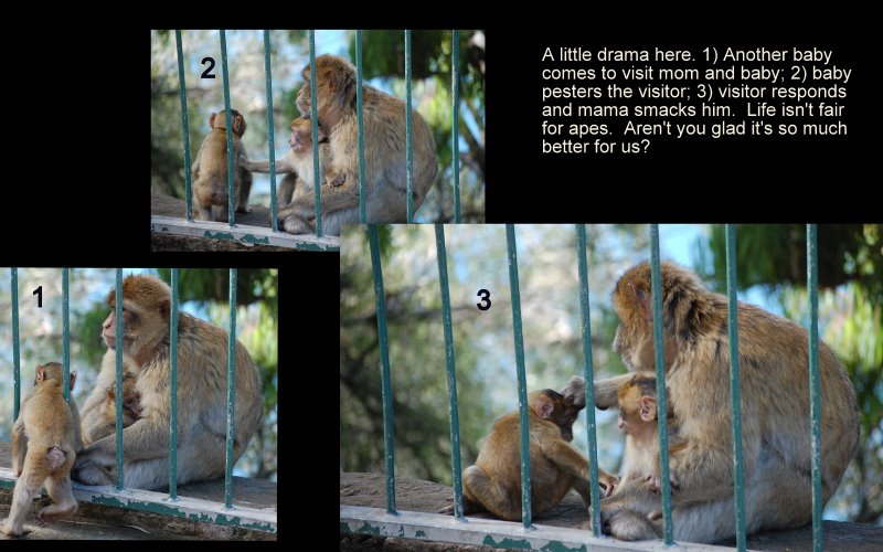
Going ape with the Barbary Macaques

About half-way up the mountain, we had our first
engagement with the Barbary Macaques who know all of the
tourist hangouts. Many incorrectly call them apes.
They are Europe's only wild monkeys although they are fed
by the government since popular myth holds that the Brits
will stay in Gibraltar until the last of the apes dies.
In fact, if it weren't for humans, these would be the
only primates in Europe (except for the Pope, of
course).
Don't assume that you are looking at adult females here.
Nearly unique among primates, males often carry around
the infants, quite remarkable when you consider that male
extracurricular behavior makes fatherhood impossible to
prove. (We'll skip the details of this monkeying around.)
The macaques spend about 20% of the day grooming each
other, but whose being picky.

When the macaque population fell to 7 during WWII,
Churchill ordered that it be augmented from Africa. (He
had that kind of time.) Today they are counted annually
and have tattoos and microchips for identification.
Today's population is around 230 and is strictly
controlled. (Don't ask how, but suffice it to say that
there is no Viagra added to bananas.)

Neanderthal spelunking

For eons, rain water mixed with carbon dioxide from both
the air and soil created a mild carbonic acid which
eventually carved huge caves into the Rock's soft
limestone. The biggest and most visited of the more than
150 caves is St. Michael's, shown here.
Many ancients considered this to be the entrance to Hades
since Gibraltar was at the end of their known world. Cave
formation was enabled by the horizontal limestone beds
being drastically shifted vertically when the African
plate crashed into Europe, isolating the Mediterranean
until it dried up. These plates continue to collide
providing us with earthquakes like that which wiped out
Lisbon in 1755.
During WWII, blasting expanded these caves as the Brits
tried to expand them; in doing so, the explosions
revealed other huge caves. (If you're into cave
pictures, try our photos of the nearby Costa del Sol
caves at Nerja
by clicking here.

Besides the apes on the outside of St. Michael's cave, we
have other primates inside. Our extinct cousins, the
Neanderthals, lived in Gibraltar's caves, perhaps as
early as 40,000 years ago. Above is a copy of an
important Neanderthal skull found at the peninsula's
Forbe's quarry 8 years before the species got its name
from the West German valley in the mid 1800s. This flashy
presentation is of a skull with a bony growth behind the
forehead characteristic of menopause, perhaps the first
fossil to evidence this condition.
Neanderthals lived here during the ice age when the Rock
would have been set back many miles from shore because
much water was locked in the ice caps. Part of their diet
was from beached dolphins stranded on the beaches. The
Neanderthals lived here long after they died out in more
harsh Northern climes.

Here's another cave view of areas enlarged during WWII to
serve as a military hospital. Never used as such, today
it's a concert hall. What would the Neanderthals think of
that? The Iberian peninsula appears to be the last refuge
of this hominid species and as its southernmost point,
Gibraltar may have been their last stand (or cave).
Carbon dating of fire pit remains here points to sporadic
Neanderthal occupation of the inside of the Rock for over
100,000 years.
Nulli expugnabilis hosti

We look here from high atop the Rock westward towards
Spain's busiest port, Algeciras. In 711 the Moors invaded
Spain from Africa (~20 miles away), but were repulsed at
Algeciras. They then came to the southern tip of this
peninsula and landed undetected. Moors then ruled here
for 7 1/2 centuries.
Here in 1607 the Dutch wiped out Spain's fleet. A hundred
years later, the Treaty of Utrecht gave this peninsula
"in perpetuity" to the Brits. For Spain, perpetuity is a
sometimes thing and they have been trying to get it back
ever since. To assist those pesky American rebels, France
and Spain sent floating batteries to bombard Gibraltar
during our War of Independence. The siege lasted 3 1/2
years and went nowhere. This place probably cannot be
taken. Most inhabitants are Spanish/English bilingual,
but their motto is the Latin "Nulli expugnabilis hosti"
--No enemy shall expel us.
Football, anyone?

This picture was taken from inside the Rock.
Notice at the base of this picture the 2 turrets
protecting 3 soccer fields -- and an airstrip that when
used shuts down the only road into the peninsula.
Victoria stadium at center holds 5000. (Typical Houston
suburban school systems have stadiums for 7000-10,000,
but the guns that protect Victoria are larger, if not as
numerous, as in Texas.)
Too small for farming, somehow Gibraltarians find room to
support 18 internationally-sanctioned sports associations
and they encourage foreign teams to practice here in the
winter. Disputes with those covetous Spaniards sometime
deny this territory its place in some international
leagues such as those sponsored by FIFA. Their cricket
team was recently best in Europe.
The British digs

In addition to the huge natural caves (some of which are
still being discovered), the British military have
created an extensive network of tunnels (called
galleries) to fortify the Rock from the inside out. The
first significant additions were created during the Great
Siege, a 3 year period when France and Spain combined to
attack an England distracted by their rebels in the
American colonies. The Brits started building the tunnels
to connect the natural ledges where they intended to
place their cannon, starting about 600 feet up the Rock.
After 6 weeks of boring, they nearly suffocated and
created a window. As soon as they did, they realized they
could poke cannon through the window and reign havoc
below. By the end of the siege, they had 6 windows
stretching over 370 feet of tunnels.
The Great Siege

The 3 1/2 year Great Siege starting in 1789 was one of
the longest battles of any war. The French and Spanish
blocked supplies from the sea while they built
fortifications outside Gibraltar. Inside rations were cut
to just above the starvation level. Occasionally, the
British fleet would break through and replenish the
garrison with men and supplies. After 2 years of this,
the Brits took half their men out on a very effective
surprise sortie. Nearly 18 months later, 70,000 French
and Spanish troops with 400 cannons (including some on
floating platforms in the bay) assaulted the
approximately 6000 British military. The Brits responded
to the new technology of floating artillery platforms
with their own invention: they heated up the cannon balls
so that they started fires on their enemy's barges once
they hit, causing rounds of explosions. In that one
assault alone, the combined French/Spanish lost over 5000
men while the Brits lost about 1200 during the entire 3
1/2 year siege.

This shaky picture is about all I could get inside the
dark tunnels. After the Great Siege, the Brits continued
to expand the tunnels, adding rooms for supplies and
ammunition. Within a decade, the system had expanded from
300 to 1000 feet. Typically they would expand cracks in
the limestone by soaking wood wedges which would expand
and crack holes large enough to stuff with gunpowder
which would then be exploded. Rings were placed in the
wall to help move the heavy cannon uphill. But the Brits
weren't the only ones to come up with great engineering
ideas to win the war. On the Spanish side, a proposal to
build a mountain adjacent to the Rock, but much higher,
was vetoed by their commander. Talk about stifling
innovation!

Mannequins help tourists to envision the action. During
the siege, each of the 6 window units had four cannon
which must have been rotated into position after cleaning
and reloading. During the blockade, ammunition supplies
could get so tight that cannon could only fire 3 times
per day. Soldiers dubbed the rounds Father, Son, and Holy
Ghost. Note the rope curtain...

...this curtain was suspended on these rings. Made of
rope or leather, these flash curtains would be wetted
down so that any sparks that would fly back into the
chamber would be extinguished before they could ignite
the gunpowder and fumes which must have been extremely
hazardous under the frenetic combat conditions.

During WWII, Gibraltar was further fortified with another
33 miles of tunnel (as opposed to 1/5 of a mile in the
1790s!). Searchlights were added to illuminate the
Strait. Mannequins impersonate the Royal Engineers who
operated the lights and their generators. They lived in
hollowed out sections of the Rock. (The British recently
declassified their secret plans to hide a few soldiers
with radios inside the Rock if it were ever captured by
the Germans who, it turned out, never even got close to
doing so.)
Thou shalt not covet thy neighbor's rock

Here's a close-up of the Rock. As you can see, this is
hardly the impregnable granite we might think. The
limestone is so soft that one local joke says that the
many Spanish workers who move across the border daily are
dismantling the Rock by carrying it back home as gravel
in their pockets.
The Spanish so wanted this place back that they allied
themselves with the French during the American Revolution
with the sole intent of securing Gibraltar's return. The
Great Siege was the 14th siege here at a time when the
Brits had only held the Rock for 75 years. In 1969,
Franco in a snit closed down traffic between Spain and
Gibraltar in what some call the 15th siege. It made
inhabitants here highly suspect of the Spanish government
for the foreseeable future.
Pillar of Hercules

Not all of Gibraltar's monuments are military based. This
one recognizes Gibraltar as being one of the pillars of
Hercules which frame the straits. The ancients thought
that the world ended here and Plato made the case
(supported by some modern scientists) that the legendary
city of Atlantis lay just offshore. This monument is near
Jew's Gate, the entrance to the Jewish cemetery.
Once they took Gibraltar, in defiance of the Treaty of
Utrecht, the British allowed Jews back after Spain
expelled them in 1492, two centuries earlier. By the time
of the American Revolution, they numbered half the
population (but are only about 2% today). A case can be
made that the Jews were more integrated into Gibraltar
than any other community in the Western world and the
vernacular language (Llanito) contains hundreds of
Jewish-derived words.
To shop is to live?

Let's leave the mountain now and look at a few sites in
the town of 27,000 or so at its base. To a large extent,
this place seems more like a mall than a town, and we
found it to be much less interesting than the history and
wildlife looming over it. The main drag is filled with
luxury boutiques made affordable by the lack of taxes.
Mediocre and high priced restaurants line the
pathways.
It has the same weather but a much different feel from
its many Spanish sister towns on the Costa del Sol. It
also has the same latitude as Las Vegas and not just
geographically as its known for its casinos and online
gambling sites. In 2006, online gambling employed 12% of
Gibraltar's work force. Despite what its mayor calls the
strongest economy in the world, the town has no college
and young people must leave for their higher
education.
Being British in Iberia, this could be a unique place --
yet it seems to lack a soul amid its creature comforts.
Its macaques and Neanderthals may have been happier.
Parting thoughts -- and places

Speaking of souls, its cathedral is unremarkable even
though, like Spain, Gibraltar is highly Roman Catholic
(78% of the population.) Most of its inhabitants have
historically Catholic populations in their ancestry,
coming from places such as Genoa, Catalonia and
Portugal.

The main plaze (Casemates Square) contains over 60
restaurants and retail stores. It's name means a
fortified position.
While the military is not that obvious in Gibraltar any
more, most streets and areas bear military names. The
town is quite vertical and basement windows look across
streets into windows of their neighbors' upper stories as
can be seen here.
When Francisco Franco closed the border in the 1960s, the
Spanish workforce that crossed into town daily was
replaced by Moroccans who were housed in this area.

Over the years, Gibraltarians have constructed tunnels to
navigate through the Rock. A side effect is that the
waste material is then dumped into the sea to expand the
peninsula, for example, to build the airport runway. This
passage leads outward from the Casemates Square to the
border with Spain -- about a 10 minute walk.

The Moorish fort flowed down the hill from the peak. Some
of the supporting structures are still in place and
clearly visible from the town.

This building is now used as a prison. The last military
execution was in 1864 -- in Casemate Square.

Another view of the Rock. The openings were created to
allow the cannon to blast anything in the Bay of
Gibraltar on the West side. (The steep East side is
pretty much impregnable). Communication towers pretty
much hold the summit nowadays. Telecommunications
constitute about 10% of Gibraltar's GDP.
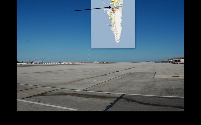
In search of the strip

Leaving the peninsula on foot to return to our car parked
in Spain, we crossed the one strip airport. Its claim to
fame is that it's the airport closest to its city center
(about 1/3 of a mile). Since Gibraltar would pretty much
fit inside of New York's Central Park, this is not
unexpected. (But you may argue that Manhattan has
sufficient Neandrathals and monkeys already.)

Gibraltar is building a tunnel for car traffic under the
landing strip. Until then, planes stop traffic for
take-offs and landings. In the distance is the Spanish
town of La Linea (which means the line of the border). As
European air travel gets cheaper and more profitable,
road shutdowns are becoming more numerous and create
congestion problems.

A bit of telescopic lens foolery above showing one of the
many freighters at the end of the runway.
In 2006, Spain finally allowed Iberia to serve this
airport. Service was later stopped for economic, not
diplomatic, reasons. British Air and the discount easyJet
still provide frequent flights to London.

The airport was built just before WWII over the Maltese
racecourse and extended into the Bay of Gibraltar,
further irritating the Spaniards who claimed the area as
theirs. From the sky, it looks a bit like an aircraft
carrier that grounded on the narrow isthmus between La
Linea and Gibraltar. if you're into panoramas,
click here.

A new terminal will be added as well. Note the non-Roman
arches at far left. Keep walking and you get to them and
La Línea de la Concepción in Spain. We
parked there and walked into this piece of Britain for
the day. So far this is the only territory we have
entered and left on foot. This looks pretty pedestrian
but wait til you get to the next (and last)
picture...

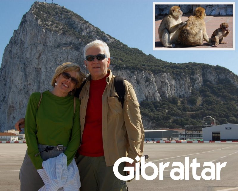
Thanks for joining us. Here's a bit of explanation for
this picture. The Barbary Apes are in the upper right;
other lifeforms (perhaps more advanced than both apes and
Neanderthals) are at lower left. These are members of the
self-extincting species called homo travelus. Their claim
is based on their more sophisticated tools. The smaller
female is wearing a pedometer and the well-nourished male
holds a remote shutter control in his right hand that he
used to take this picture before the wind blew the tripod
over. See all of these primates' travel pictures
by clicking
here.


